

There are five national parks in Utah (the so-called “Mighty 5”): Arches, Bryce Canyon, Canyonlands, Capitol Reef, and Zion.

A few years ago my husband and I visited Zion and Bryce; this summer we traveled to Arches and Canyonlands.
Of the four Utah parks we’ve explored, there are some notable similarities.
They are hot.
They are colorful.
They are rocky.
They are majestic.
Yet each has something unique that distinguishes it from the others.
Arches reveals its claim to fame right there in its name. It is a high-desert marvel of red rock cliffs, fins, buttes, monoliths, spires, and, well, more than 2,000 arches. One of the fun things about the park is discovering doppelgangers in the rock formations. Many of the rocks resemble others things; it’s kind of like seeing shapes in the clouds.
Some of the formations already have names, like:
Elephant Butte…

and Three Gossips.

Can you tell what the next one is? It’s a little tougher. Scroll down to the bottom for the answer.

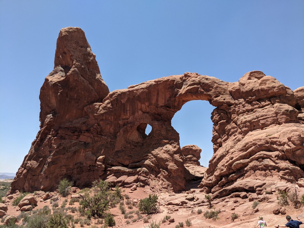
Many of the arches have names as well, like Double Arch and Turret Arch.

In general the names are appropriately descriptive, sometimes amusing or whimsical. There are a few arches, however, that didn’t seem to correspond to their names at all! Read on to find out more about three distinct Arches experiences, featuring plenty of marvels and a few misnomers.
Delicate Arch
Delicate Arch is probably the most iconic sight at Arches. It is showcased on the Utah license plate, after all!
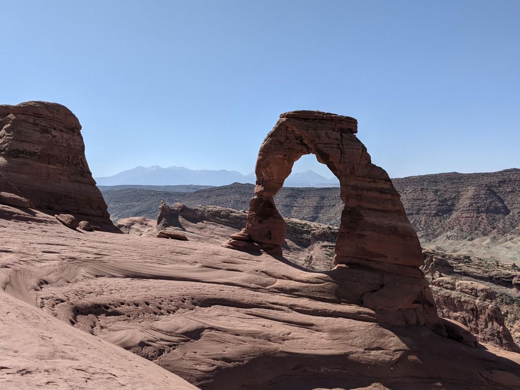

There are two ways to experience the arch. One is by accessing the Upper or Lower Viewpoint trails, which are short and easy, with the tradeoff that you get only a very distant view of the arch. The other option is to hike the three-mile Delicate Arch trail, a moderately difficult trek up exposed slickrock hills and narrow windswept ledges.

The reward at the end of this trail is fantastic views of the arch, with the tradeoff that you will get buffeted by 30 mph gusts of wind. It is intense. At the top, children burrowed into their parents’ chests, trying to avoid the sand blasting their faces. The rest of us staggered around trying not to get blown off the cliff as we posed for pictures.

I’m not sure how this arch got named “delicate,” because to me it seemed anything but. I guess it is a bit more slender than some of the arches, and it is perched rather delicately at the top of the bluff, but to withstand the relentless wind up there? Whew. Pretty stout.
Landscape Arch
Perhaps they’d had a little too much sun on the day they were naming arches, because Landscape Arch is actually much more delicate and graceful than Delicate Arch. Spanning almost 300 feet, this ribbon of rock is the longest natural stone arch in the United States and one of the longest in the world.
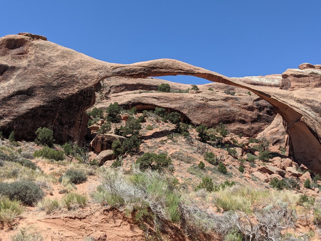
It wasn’t always quite so slender though. In the 1990s several slabs and chunks of rock broke off and fell from the arch, reducing its girth and necessitating closure of the trail passing underneath it. Landscape Arch is one of many in the Devils Garden section of the park, and you can enjoy its beauty by hiking a relatively easy one-mile (each way) trail. Short spurs nearby lead to a few other arches, like Pine Tree Arch. Which, aptly enough, features a tiny pine tree beneath it.
If we someday return to Arches, I would like to explore the Devils Garden area more thoroughly. There are about eight miles of trails, with rocks and fins to scramble on and hidden arches to discover. With temperatures hovering around 100 degrees on the days we were there, it was simply too hot to hike around all of it.
Tapestry Arch
I have a theory about the trails at national parks. I think that every park has one trail that the rangers agree to downplay and keep quiet, allowing for adventurous hikers to discover and delight in its unexpected solitude and beauty. That trail at Arches is—should I reveal it?? I must. It’s the Sand Dune Arch-Broken Arch-Tapestry Arch trail. And I’m not going to complain about these arch names. Sand Dune and Broken are pretty spot-on. “Tapestry” is kind of bland and uninspiring, but that’s how we’ll keep too many people from finding it, see? We’ll deploy the ol’ Iceland / Greenland naming strategy.
Here’s how our hike unfolded. By the end of our second day at Arches, we were pretty depleted by the cumulative effects of the heat, wind, and elevation. Feeling like our work at Arches was complete, we began driving out of the park. But then we noticed the turnout for Sand Dune Arch, which is billed as a short easy hike. Why not stop and see one last arch before leaving?
We walked the sandy 0.3 mile trail to Sand Dune Arch.

Then we noticed that across the meadow (just another mile) Broken Arch beckoned. Well, since it was right there, we walked over.
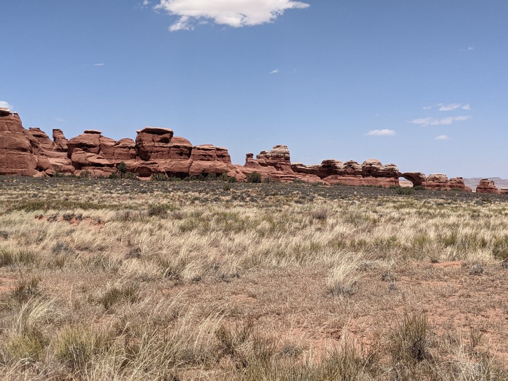
Once we arrived, there was signage that encouraged hikers to climb through the arch to continue on the trail. We figured we should climb up just to take a look . . . but then we kept walking. I mean, at this point it was just a little farther to the third arch, Tapestry Arch.
This was where the trail really turned magical. How was it possible that in a park with hundreds of visitors, we had this trail all to ourselves? We didn’t encounter another soul (except for some lizards) as we followed the carefully-situated cairns to Tapestry Arch. Without the cairns we would have gotten hopelessly lost as we scrambled up and down and over and through the rocks and hills. When we got to the arch we clambered up into its cool recess to sit and marvel at the landscape and the quiet.

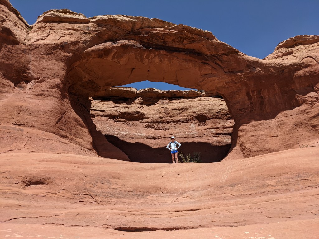
It turned out to be the perfect hike to cap off our visit to Arches. It was an unexpected adventure, but often those are the best ones.
I know we’ve got another visit to Utah somewhere in our future, because Capitol Reef is still on the must-see list of parks. When we go, I’d love to stop at Arches again and discover even more of its hidden gems.
Two things to know before you go:
1. Like several other national parks, Arches is piloting a timed entry system during peak months of the year. You must have a reservation to enter the park. They say that the goal is not to reduce the number of visitors, but rather to spread them out more evenly throughout the day, to reduce congestion at the entrance station, in parking lots, and on the trails. Be sure to check the website several months in advance of your visit to make sure that you get your pass, if necessary!
2. Download the National Park Service app. It’s incredible. You’ll find alerts, maps, things to see/do, locations of passport stamps. And one of my favorite parts—a fun little feature that allows you to create virtual “postcards” to send to friends and family.
Answer: Sheep Rock
